Temperatures soaring into the 30s and damaging wind gusts have prompted authorities in New South Wales to raise bushfire alerts to their highest levels in more than two years, as thunderstorms roll into Sydney.
More than 20 public schools across central NSW were closed on Wednesday after the state’s Rural Fire Service issued a warning for catastrophic fire danger.
Temperatures were forecast to reach a top of 36C in Sydney, and pass 40C in Bourke, in the state’s north-west.
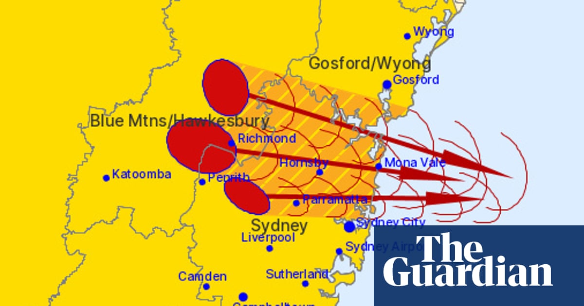
Soon after midday, the Bureau of Meteorology issued a warning for severe thunderstorms heading east, with the potential for damaging winds and large hailstorms. They were forecast to affect Richmond, Colo Heights, St Marys and the Wollemi national park west of Putty, moving to Hornsby, Parramatta and Windsor and then Mona Vale, Cessnock and Branxton.
Sign up: AU Breaking News email
Earlier in the day, the lower central west plains – including the regional hubs of Dubbo, Parkes and Forbes – were warned of the highest level of bushfire conditions, meaning people there should consider leaving fire risk areas and stay out of paddocks and bushland.
No region of NSW has had a catastrophic fire danger forecast since September 2023.
Extreme danger warnings were also declared for millions of residents, including those in metropolitan Sydney, as wind gusts of more than 90km/h were expected on Wednesday in southern NSW and Victoria.
“Severe storms are possible right along the coast,” Bureau of Meteorology’s Miriam Bradbury said.
Sign up: AU Breaking News email
“That extends from the southern parts of the Cape York Peninsula all the way through the eastern districts of Queensland and into the south-east, then pushes down across north-east and central NSW.
“So really, for communities which have already seen a few days of very strong, severe storms, this is yet another day of very unsettled weather.”
Large parts of Queensland continue to swelter under heatwave conditions, with temperatures 6C to 10C above the November average.
Greg Allan, a spokesperson for NSW Rural Fire Service, said the combination of strong winds, high temperatures and low humidity, together with dry vegetation, meant fires could start quickly and spread rapidly.
For those living or working in the lower central west, where catastrophic conditions were forecast, he said: “It’s important to know that homes could be lost if a fire takes hold.”
after newsletter promotion
There were 24 bush and grassfires burning on Wednesday morning and all but three were contained, Allan said. Peak fire conditions were expected between 1.30pm to 6pm.
Residents in affected areas were advised to keep up to date with advice from emergency services and the BoM.
“The most important thing is, for those in the areas of extreme and definitely in the area of catastrophic fire danger, to have that discussion with your loved ones, or those on your property, about what you’ll do if there is a fire,” he said. “Leaving early is always the safest option, particularly in the catastrophic area.”
The BoM’s Sarah Scully said: “[Winds are] combining with warm to hot temperatures and really dry air and that is elevating fire dangers across the region.”
Total fire bans were in place across much of NSW, and an elevated fire danger was also forecast in the southern interior of Queensland.
The warnings of increased bushfire danger come as the countryreels from a deadly start to bushfire season.
Country Fire Service member and 30-year firefighter Peter Curtis died on Sunday while battling a scrub fire on the Eyre Peninsula in South Australia. Another bushfire in north-east Tasmania has burned since Saturday, with authorities advising people in the Curries River reservoir area to monitor conditions.